
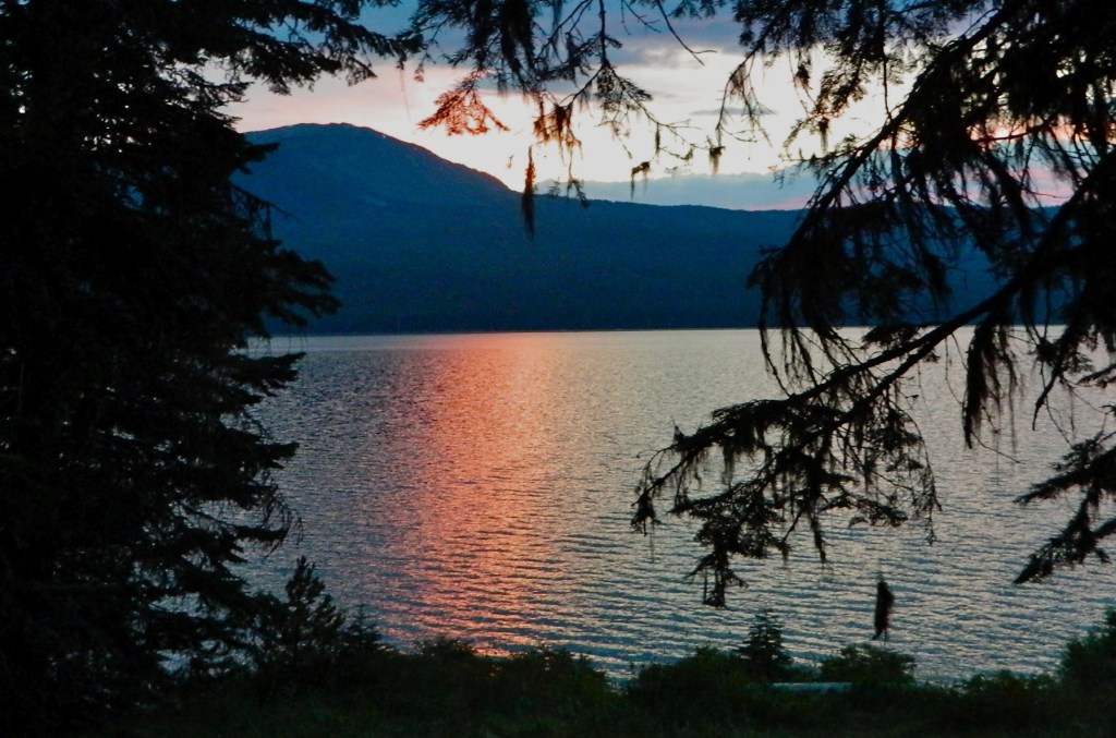
Each morning Mount Bailey stands silently in the shadows across the still waters of Diamond Lake until the sunlight slowly slides from its peak to its base, revealing a glistening masterpiece reflecting on the mirror surface.
The grand peak rises to 8,368 above sea level, just more than 3,000 feet above the mile-high Diamond Lake.
As I sip coffee in front of my campfire soaking in this tremendous view with Osprey gliding above the waters and eventually shattering the stunning reflection with a dive to snatch a squirming Rainbow Trout from the water, I’m itching hop on my bike and explore.
After a morning hike with my daughter Taylor, I hit the paved path that circles the lake, and stop for a moment at Teal Lake, named for the incredible shade of green projected by the algae in the water and the surrounding Douglar Firs.
I continue on to Silent Creek, with water so clear you really have to wonder if you’re dreaming or not. It’s the only creek I’ve ever sat next to without hearing a peep from it.
The Silent Creek Trail follows the creek upstream away from Diamond Lake’s trail. It’s a paved path until you cross the road toward the real trailhead.
Then you hit beautiful single-track that winds over nine wooden bridges that slip over as many tributaries. It’s not overly technical nor hilly. Just silent and idyllic.
After 1.5 miles of peaceful bliss, I hit the Mount Bailey trailhead, hidden somewhere in the middle of the Umpqua National Forest. A few dirt fire roads lead to it, but I imagine you’d never find it otherwise. The sign says 1.5 miles to the Diamond Lake overview and 4.5 miles to the summit.
I’m game.
I disappear into the forest for a half-mile of rollers before beginning an ascent that is generally a straight shot. It’s brutally tough on the psyche to see nothing but climbing straight ahead for as far as your eye can see in the woods, rather than not knowing what’s around the next curve — the reality of real MOUNTAIN mountain biking slapping you upside the head.
As usual, you have to climb the mountain first, usually with an hour or more of climbing, followed by a turnaround and a 20-30 minute descent down the same trail. You can opt for ski resorts and take a chairlift, I suppose. That’s not my cup of tea.
This climb is brutal. I thought I was in pretty good shape, but this trail kicks my ass. Hard. It’s just a pinch too steep for me to get into a steady, uninterrupted rhythm like I can do on a paved or gravel logging road.
The dry, mid-summer loose dirt and gravel keeps me in the saddle. The climb bangs me hard when I realize, hey, I still haven’t gotten to that 1.5-mile overview! At least as far as I know.
Shortly after that thought, the lake pops into view between the trees. I imagine an all-out clear view somewhere, hopefully with a neat wooden carved sign, so I keep humping. The trail turns, the view disappears, and it levels off for the first time in, well, probably 1.5 miles.
Given that reprieve, there’s no stopping for a view or photo op. I power on, eventually crossing another fire road before the trail gets real steep again.
Walking steep.
I hike up about 100 yards, and it levels off again. This tantalizing pattern repeats itself over and over as my fuel reserves fall quickly.
You see, Taylor and I bypassed breakfast for our morning 3-mile hike. We did share a Clifbar along the way. When we got back, I had a few handfuls of tortilla chips and jumped on my bike. That’s what I have in the tank.
Finally the trail hits the wall. It’s so steep it would be unrideable in both directions, up or down. At least for me.
I keep hiking the bike up and up, hoping to get some sort of closure on the experience. That’s when Mount Theisen pops into a view.
Huge, pointy peaks speckled with snow against the cloudless blue sky. While our view across Diamond Lake to the west offers Mount Bailey, Mount Theisen — at more than 9,000 feet — towers over us to the east. We can’t see it from our site because of the trees.
Continue the panoramic view, and you see Mount Mazama, otherwise known as the volcano that blew its top, tumbled in and created the caldera for Crater Lake.
Way off to the south, the distant peak with all the snow? That has to be Shasta. Pay-off.
Hours later, again alongside the campfire, we watch the sun disappear behind Mount Bailey as perfect, orange, red and blue layered sunset surrenders us back into silence.
“Daddy, you rode all the way up to the top of that?” Taylor asks.
“Almost,” I reply, the mountain’s majesty demanding honesty, “Almost …”
Time to ride.